Malawi is divided into three geographical regions: the central region, the northern region, and the southern region. It is divided into 28 districts under three geographical regions. These districts are the highest administrative division of Malawi. 9 of the 28 districts are located in the central region, 6 in the north and 12 in the southern region.
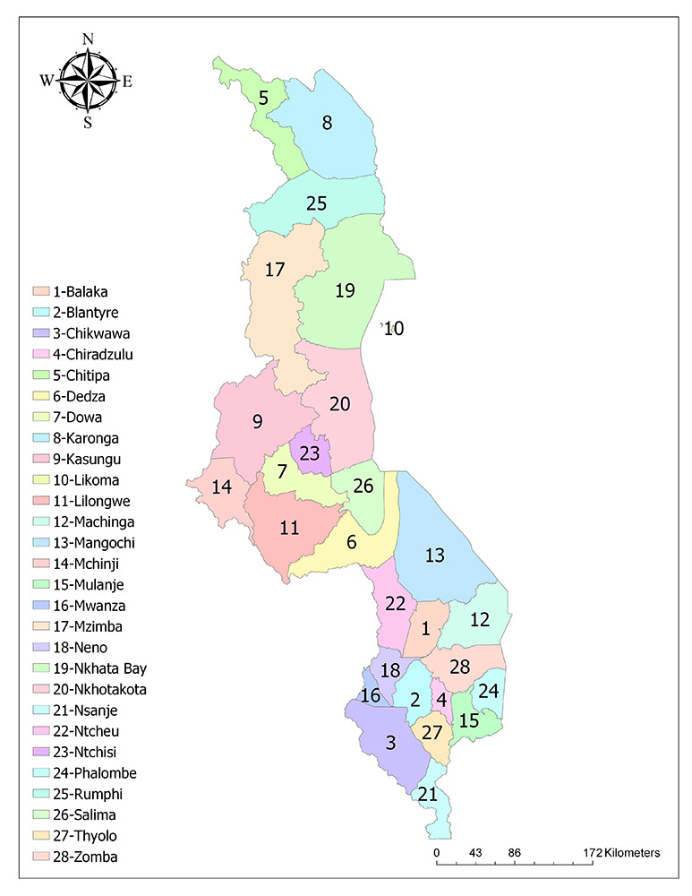
Twenty-Eight Districts of Malawi
Malawi is divided into 28 districts as the highest administrative division. These districts are Dedza, Dowa, Kasungu, Lilongwe, Mchinji, Nkhotakota, Ntcheu, Ntchisi, Salima, Chitipa, Karonga, Likoma, Mzimba, Nkhata Bay, Rumphi, Balaka, Blantyre, Chikwawa, Chiradzulu, Machinga, Mangochi, Mulanje, Mwanza, Nsanje, Thyolo, Phalombe, Zomba, and Neno.
Dedza
Dedza is one of the 28 districts of Malawi. Dedza is located in one of the three regions of the country and it is one of the districts of the country which is on the shores of Lake Malawi. The town center is Dedza, which is the same name as the general district. To the east of the district is the Malawi Lake and Mangochi district, in the north the district of Salima, the Lilongwe district in the west, the Ntcheu district in the south and the neighboring Mozambique state. According to the official state data of 2008, the area of the district where 623,789 inhabitants live is 3,624 square kilometers.
Dowa
Dowa is one of the 28 districts of the African country Malawi. Dowa is located in the Central region, which is one of the three regions of the country. The central city of the district is the city of Dowa of the same name. Salima district is located to the east of the district. It is adjacent to Ntchisi and Kasungu in the north and Lilongwe County in the southwest. According to the official government data of 2008, the district where 556,678 inhabitants live has an area of 3,041 square kilometers.
Kasungu
Kasungu is one of the 28 districts of the African country Malawi. Kasungu is located in the Central region, which is one of the three regions of the country and constitutes the second largest district in terms of area of the country. Nkhotakota district is located in the east, Mzimba district in the north, Lilongwe district in the south, Mchinji district in the southwest, Dowa district and Ntchisi district in the southeast and Zambian state in the west. According to 2008 official government data, the district has a population of 616,085 and has a surface area of 7,878 square kilometers.
Lilongwe
Lilongwe is one of the 28 districts of the African country Malawi. Lilongwe is located in the Central region, which is one of the three regions of the country and constitutes the most populous district in terms of population. The central city of the district is Lilongwe, which is also the capital of Malawi.
The district is adjacent to Mchinji district and Mozambique in the west, Dowa district and Kasungu in the north, Dedza district and Salima district in the east and Mozambique in the south. According to the official government data of 2008, the district has a population of 1,897,167 inhabitants and its surface area is 6,159 square kilometers.
Mchinji
Mchinji is one of the 28 districts of the African country Malawi. Mchinji is located in the Central region, which is one of the three regions of the country. The central city of the district is the city of Mchinji, which has the same name as the general district. The district is adjacent to Kasungu district in the northeast, Lilongwe district in the southeast and Zambian state in the west. According to official government data of 2008, the district has a population of 456,558 and has a surface area of 3,356 square kilometers.
Nkhotakota
Nkhotakota is one of the 28 districts of the African country Malawi. Nkhotakota is located in the Central region, which is one of the three regions of the country and constitutes one of the districts of the country that is located on the shores of Lake Malawi. The central city of the district is the city of Nkhotakota, which has the same name as the general district. To the east of the district is Lake Malawi. It is adjacent to Mzimba and Nkhata Bay in the north, Kasunga, and Ntchisi in the west and Salima in the south. According to 2008 official government data, the district has a population of 301,868 and has a surface area of 4,259 square kilometers.
Ntcheu
Ntcheu is one of the 28 districts of the African country Malawi. Ntcheu is located in the Central region, which is one of the three regions of the country. Mangochi district and Balaka district are located in the east of the district, while Dedza district in the north, Mwanza district in the south and Mozambique state in the west. According to the official government data of 2008, the district has a population of 474,464 inhabitants and an area of 3,424 square kilometers.
Ntchisi
Ntchisi is one of the 28 districts of the African country Malawi. Ntchisi is located in the Central region, which is one of the three regions of the country. The district is adjacent to Nkhotakota district to the east, Kasungu district to the northwest, Salima district to the southeast and Dowa district to the south. According to the official government data of 2008, the district with a population of 224,098 inhabitants is 1,655 square kilometers.
Salima
Salima is one of the 28 districts of the African country Malawi. Salima is located in the Central region, which is one of the three regions of the country and constitutes one of the districts of the country that is located on the shores of Lake Malawi. Lake Malawi is located to the east of the district, while Nkhotakota district in the north, Ntchisi district in the northwest, Dowa district and Lilongwe district in the west, and Dedza district in the south. According to 2008 official government data, the district has a population of 340,327 inhabitants and an area of 2,196 square kilometers.
Chitipa
Chitipa is one of the 28 districts of the African country Malawi. Chitipa is located in the Northern region, which is one of the three regions of the country and constitutes the district in the northernmost part of the country. The district is adjacent to Karonga district in the east, Rumphi district in the south, Tanzania in the north and Zambia in the west. According to the official government data of 2008, the district has a population of 179,072 and its surface area is 4,288 square kilometers. The district is one of the districts with the lowest density in Malawi in terms of population density.
Karonga
Karonga is one of the 28 districts of the African country Malawi. Karonga is located in the northern part of the country, which is located in the northern part of the country. The district is adjacent to Lake Malawi in the east, Rumphi in the south, Tanzania in the north and Chitipa in the west. According to 2008 official government data, the district has a population of 272,789 inhabitants and an area of 3,355 square kilometers.
Likoma
Likoma is one of the 28 districts of the African country Malawi. The district consists of two small islands, Likoma and Chizumulu islands, which are 10 km away from each other, and is the smallest county in terms of the area. The islands on the Lake Malawi, which is under the domination of Mozambique, are the settlements of Malawi within the borders of other countries. The mainland section is 46 km from Chizumulu and 55 km from the nearest mainland port. In contrast, the mainland of Mozambique is 5 km from the islands. According to the official government data of 2008, the district has a population of 10,445 and its surface area is 18 square kilometers.
Mzimba
Mzimba is one of the 28 districts of the African country Malawi. Mzimba is located in the Northern region, which is one of the three regions of the country and constitutes the most populous district in the northern part of the country. The central city of the district is the city of Mzimba, which has the same name as the general district. The district is adjacent to Nkhata Bay district in the east, Rumphi district in the north, Nkhotakota district, and Kasungu district in the south, and Zambia in the west. According to 2008 official government data, the district has a population of 724,873 and the surface area is 10,382 square kilometers.
Nkhata Bay
Nkhaba Bay or Nkhatabay is one of the 28 districts of the African country Malawi. Nkhaba Bay is located in the Northern region, which is one of the three regions of the country, and its central city is Nkhaba Bay. The district is adjacent to Mzimba district in the west, Nkhotakota district in the south and Rumphi district in the north and Lake Malawi is located in the eastern part. According to the official government data of 2008, the district has a population of 213,779 and its surface area is 4,071 square kilometers.
Rumphi
Rumphi is one of the 28 districts of the African country Malawi. Rumphi is located in the Northern region which is one of the three regions of the country and constitutes the district in the northernmost part of the country. The district is adjacent to Karonga district and Chitipa district in the north, Mzimba district and Nkhata Bay district in the south, Lake Malawi in the east and Zambia in the west. According to the official government data of 2008, the district has a population of 179,072 and its surface area is 4,288 square kilometers.
Balaka
Balaka is one of the 28 districts of the African country Malawi. Balaka is located in the Southern region, one of the three regions of the country. Machinga is located to the east, Mangochi to the north, Ntcheu to the west, Mwanza to the south and Zomba to the south. According to the official government data of 2008, the district has 316,748 inhabitants and its surface area is 2,193 square kilometers.
Blantyre
Blantyre is one of the 28 districts of the African country Malawi. Blantyre is located in one of the three southern regions of the country, and Blantyre city center is the second most populous city in the country. The district is adjacent to Mwanza district in the northwest, Zomba district in the northeast, Chiradzulu district in the east, Chikwawa district in the southwest and Thyolo district in the south. According to 2008 official government data, the district has a population of 999,491 inhabitants and its surface area is 2,012 square kilometers.
Chikwawa
Chikwawa is one of the 28 districts of the African country Malawi. Chikwawa is located in the Southern region, which is one of the three regions of the country. Thyolo district in the east, Blantyre district in the northeast, Mwanza district in the north, Nsanje district in the southeast, Mozambique state in the west and south. The district is the second largest district in terms of surface area in the southern part of the country and ranks sixth in the country. According to 2008 official government data, the district has a population of 438,895 inhabitants and an area of 4,755 square kilometers. Chikwawa is one of the 28 districts of the African country Malawi. Chikwawa is located in the Southern region, which is one of the three regions of the country. The district is neighbor with Thyolo district in the east, Blantyre district in the northeast, Mwanza district in the north, Nsanje district in the southeast, Mozambique state in the west and south. The district is the second largest district in terms of surface area in the southern part of the country and ranks sixth in the country. According to 2008 official government data, the district has a population of 438,895 inhabitants and an area of 4,755 square kilometers.
Chiradzulu
Chiradzulu is one of the 28 districts of the African country Malawi. Chiradzulu is located in the Southern region, which is one of the three regions of the country. The district is adjacent to Mulanje district in the east, Thyolo district in the south, Zomba district in the north and Blantyre district in the west. According to 2008 official government data, the district has a population of 290,946 inhabitants and has a surface area of 767 square kilometers.
Machinga
Machinga is one of the 28 districts of the African country Malawi. Machinga is located in the Southern region, which is one of the three regions of the country. The district is located in the east of Mozambique, while Mangochi district in the north, Zomba district in the south and Balaka district in the west. According to the official government data of 2008, 488,996 inhabitants have a surface area of 3,771 square kilometers.
Mangochi
Mangochi is one of the 28 districts of the African country Malawi. Mangochi is located in the Southern region, which is one of the three regions of the country and constitutes the largest district in this region of the country. Lake Malawi lies to the north of the district, while Dedza and Ntcheu to the west, Machinga to the south and Balaka to the south, and Mozambique to the east. According to the official government data of 2008, 803,602 inhabitants have a surface area of 6,273 square kilometers.
Mulanje
Mulanje is one of the 28 districts of the African country Malawi. Mulanje is located in the Southern region, which is one of the three regions of the country. The district is adjacent to Phalombe district in the east, Zomba district in the north, Chiradzulu district and Thyolo district in the west and Mozambique state in the south. According to the official government data of 2008, the district has a population of 525,429 and its surface area is 2,056 square kilometers.
Mwanza
Mwanza is one of the 28 districts of the African country Malawi. Mwanza is located in the Southern region, which is one of the three regions of the country. Neno district and Blantyre district are located to the east, while Ntcheu district to the north, Chikwawa district to the south and Mozambique state to the west. According to 2008 official government data, the district has a population of 94,476 and has a surface area of 2,295 square kilometers.
Nsanje
Nsanje is one of the 28 districts of the African country Malawi. Nsanje is located in the Southern region, which is one of the three regions of the country and constitutes the district in the southernmost part of the country. The district is adjacent to Chikwawa district and Thyolo district in the east, while it is surrounded by Mozambique state in the west, south, and east. According to the official government data of 2008, 238,089 inhabitants have an area of 1,942 square kilometers.
Thyolo
Thyolo is one of the 28 districts of the African country Malawi. Thyolo is located in the Southern region, which is one of the three regions of the country. The district is adjacent to Mulanje district in the east, Nsanje district in the south, Chiradzulu district and Blantyre district in the north, Chikwawa district in the west and Mozambique state in the southeast. According to 2008 official government data, the district has a population of 587,455 inhabitants and has a surface area of 1,715 square kilometers.
Phalombe
Phalombe is one of the 28 districts of the African country Malawi. Phalombe is located in the Southern region, which is one of the three regions of the country. Mozambique is located in the east of the district, while Zomba in the north and Mulanje in the southwest. According to the official government data of 2008, 313,227 inhabitants have a surface area of 1,394 square kilometers.
Zomba
Zomba is one of the 28 districts of the African country Malawi. Zomba is located in the Southern region, which is one of the three regions of the country and constitutes the district in the northernmost part of the country. The district is adjacent to Balaka district and Machinga district in the north, Mwanza district and Blantyre district in the west, Chiradzulu district in the south, Mulanje district and Phalombe district, and Mozambique in the east. According to official government data of 2008, the district has a population of 670,533 and an area of 2,580 square kilometers.
Neno
Neno is one of the 28 districts of the African country Malawi. Neno is located in the Southern region, which is one of the three regions of the country. The district is located in the east of Blantyre district and Zomba district, while in the north Balaka district and Ntcheu district, in the west is adjacent to Mwanza district. While the territory of the district was a part of Mwanza district until 2003, Neno district was formed from the eastern parts of Mwanza district with the change of local administration. According to 2008 official government data, the district has a population of 108,897 inhabitants and a surface area of 1,469 square kilometers.