The Districts of Mauritius is the second-level administrative division after the country’s islands. The country is divided into nine districts. These nine districts are subdivided into 1 city, 4 towns and 130 villages. Until 2002, the country was divided into ten districts. Rodrigues Island was the tenth region of Mauritius, and in 2002 it gained autonomous status.
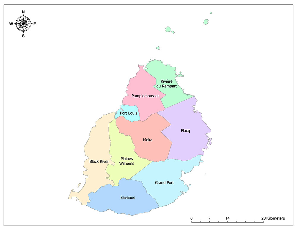
Nine Districts of Mauritius
Mauritius is divided into nine districts as a second level administrative division. Districts of Mauritius are Flacq, Grand Port, Moka, Pamplemousses, Plaines Wilhems, Port Louis, Rivière du Rempart, Rivière Noire and Savanne.
Flacq
Flacq is one of nine administrative districts on the central island of Mauritius, the African country. Although Flacq is the largest administrative region of the country with a surface area of 298 square kilometers, it is the third largest population in terms of population. The district is located in the eastern part of the island. According to the 2011 official census, 135,406 people live in the district. Auxle aux Cerfs, which is one of the most important spots for country tourism, is located in the district. This point is a small islet connected to the central island can be reached by boat.
Grand Port
Grand Port is one of the nine administrative districts on the central island of Mauritius, the African country. Although the Grand Port area is the second largest administrative region of the country with a surface area of 260 square kilometers, it is the fifth largest population among the administrative regions in terms of population. The District is located in the southeastern part of the island. According to the 2011 official census, 110,907 people live in the district. Sir Seewoosagur Ramgoolam International Airport, the island’s international airport, is located in this region.
Moka
Moka is one of the nine administrative regions on the central island of Mauritius, the African country. Although Moka is the fifth largest administrative region of the country with a surface area of 221 square kilometers, it is the seventh largest district in terms of population. The District is located in the central part of the island, along with Plaines Wilhems, which is one of the two coastal areas. According to the 2011 official census, 82,301 people live in the district.
Pamplemousses
Pamplemousses is one of the nine administrative districts on the central island of Mauritius, the African country. Although Pamplemousses is the seventh largest administrative region of the country with a surface area of 179 square kilometers, it is the second largest in terms of population. The region is located in the north of the island. According to the 2011 official census, 136,268 people live in the region. The area includes the Sir Seewoosagur Ramgoolam Botanical Garden, one of the oldest botanical gardens in the world.
Plaines Wilhems
Plaines Wilhems is one of the nine administrative districts on the central island of the African country Mauritius. Although Plaines Wilhems is the sixth largest administrative region of the country with an area of 205 square kilometers, it is the region with the largest population in terms of population. The region is located in the middle part of the island and it is one of the two regions that do not have a coast. According to the 2011 official census results, 362,292 people live in the region. The country’s four most populous cities after the capital in terms of population are within the borders of this region.
Port Louis
Port Louis is one of the nine administrative districts on the central island of Mauritius, the African country. Although Port Louis is the smallest administrative region of the country with a surface area of 43 square kilometers, it is the fourth largest population in terms of population. The district is located in the northwestern part of the island and the capital of the country is on this district. According to the 2011 official census, 118,431 people live in the district.
Rivière du Rempart
Riviere du Rempart is one of the nine administrative districts on the central island of Mauritius, the African country. Riviere du Rempart is the second smallest administrative region of the country with a surface area of 148 square kilometers and is the sixth largest among the administrative regions in terms of population. The District is located in the northern part of the island. According to the 2011 official census, 106,267 people live in the district.
Rivière Noire/Black River
Black River is one of the nine administrative districts on the central island of the African country Mauritius. Although Black River is the third largest administrative region of the country with a surface area of 259 square kilometers, it is the least populated region in terms of population. The District is located in the western part of the island. According to the 2011 official census results, 76,605 people live in district.
Savanne
Savanne is one of the nine administrative districts on the central island of Mauritius, the African country. Although the Savanne district is the fourth largest administrative region of the country with a surface area of 245 square kilometers, it is the district with the lowest population in terms of population. The district is located in the southern part of the island. According to the 2011 official census results, 67,906 people live in the district.