Namibia, located in the south of the African continent, is divided into 14 administrative regions. Although each region has limited powers, it has regional administrations. After the independence of the country in 1992, the First Delimitation Commission divided the country into 13 regions. The Fourth Delimitation Commission amended this number to 14 regions in 2014.
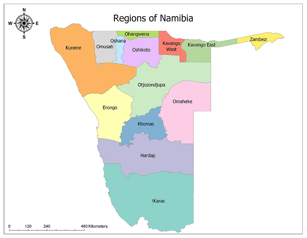
Fourteen Regions of Namibia
Namibia is divided into 14 regions, the highest administrative division. Regions of Namibia are Kunene Region, Omusati Region, Oshana Region, Ohangwena Region, Oshikoto Region, Kavango West, Kavango East, Zambezi Region, Erongo Region, Otjozondjupa Region, Omaheke Region, Khomas Region, Hardap Region and ǁKaras Region.
In November 2012, it was announced that Oshikoto and Kavango regions were planned to be divided into two new regions, and within the scope of this announced plan, on 8 August 2013, the Kavango region was eliminated and the Kavango East and Kavango West regions were formed. Furthermore, the name of the Karas region was changed to ǁKaras and the name of the Caprivi region was changed to Zambezi.
Each of the regions of Namibia is further divided into electoral constituencies, whose size is determined by the population and size of the region. There are currently 121 electoral constituencies in Namibia.
Kunene Region
Kunene is one of the fourteen regions of Namibia. Although the Kunene region is the second largest in the country in terms of surface area, it has a relatively low density in terms of population. The region is adjacent to the Atlantic Ocean in the west, Omusati, Otjozondjupa in the east, Erongo in the south, Oshana and Oshikoto in the north, as well as Angola. The administrative capital of the region is Opuwo. According to 2011 data, 88,300 people live in the region. With this population, the region, which constitutes a small portion of Namibia’s population, is the second largest region in the country with an area of 144,254 square kilometers.
Omusati Region
Omusati is one of the fourteen regions of Namibia. The Omusati region is one of the smallest regions in the country in terms of surface area and has the third highest population density. The region is adjacent to Kunene in the west and south, Hardap in the north, Oshana and Ohangwena in the east and Angola in the north. The region is also the birthplace of Sam Nujoma, the first post-independence president of Namibia and a 15-year mandate. The administrative capital of the region is Outapi. According to 2011 data, 242,900 people live in the region. The area is the largest in the country with a surface area of 26,551 square kilometers.
Oshana Region
Oshana is one of the fourteen regions of Namibia. The Oshana area is the smallest in terms of the area and has an average density in terms of population. The region is adjacent to Omusati in the west, Ohangwena in the north, Oshikoto in the east and Kunene in the south. The administrative capital of the region is Oshakati. According to 2011 data, 174,900 people live in the region. The area is the largest in the country with an area of 8,647 square kilometers.
Ohangwena Region
Ohangwena is one of the fourteen regions of Namibia. Ohangwena region is the second smallest area after the Oshana region in terms of area and has the second largest density in terms of population. Ohangwena is the second most populated region after the Khomas region, including the capital Windhoek. The region is adjacent to Omusati in the west, Oshana and Oshikoto in the south, Kavango in the east and Angola in the north. The administrative capital of the region is Eenhana. According to 2011 data, 245,100 people live in the region. The region is the second smallest region of the country with a surface area of 10,706 square kilometers.
Oshikoto Region
Oshikoto is one of the fourteen regions of Namibia. The Oshikoto region is one of the smallest areas of the country in terms of surface area and has the fifth largest density in terms of population. The region is adjacent to Oshana in the west, Ohangwena in the north, Kavango in the east, Otzojondjupa in the southeast, and Kunene in the southwest. Omuthiya is the administrative capital of the region. According to 2011 data, 181,600 people live in the region. The area is the largest in the country with an area of 38,685 square kilometers.
Kavango West
Kavango West is one of the fourteen regions of Namibia. Its capital is Nkurenkuru. The region was founded in 2013 when the Kavango Region was divided into Kavango East and Kavango West. The area of the region is 23,166 square kilometers and the population is 107,905 according to 2011 data.
Kavango East
Kavango East is one of the fourteen regions of Namibia. Its capital is Nkurenkuru. The region was founded in 2013 when the Kavango Region was divided into Kavango East and Kavango West. The area of the region is 25,576 square kilometers and the population is 115,447 according to 2011 data.
Zambezi Region
Zambezi is one of the fourteen regions of Namibia. The Zambezi region is the smallest region of the country in terms of surface area and has a very low density in terms of population. The region is adjacent to Kavango East in the west, Botswana in the south, Angola and Zambia in the north. The Zimbabwe border, which is said to be a 100-meter border east of Namibia and thus to the east of Zambezi, is controversial. The administrative capital of the region is Katima Mulilo. According to 2011 data, 90,596 people live in the region. The region is one of the smallest regions of the country with an area of 19,532 square kilometers.
Erongo Region
Erongo is one of the fourteen regions of Namibia. Erongo region is the smallest region in terms of the area and has a very low density in terms of population. The region is adjacent to the Atlantic Ocean in the west, Hardap in the south, Kunene in the north, Khomas and Otjozondjupa in the south. The administrative capital of the region is Swakopmund. According to 2011 data, 63,539 people live in the region. The region is one of the mid-sized regions of the country with an area of 150,400 square kilometers.
Otjozondjupa Region
Otjozondjupa is one of the fourteen regions of Namibia. The region of Otjozondjupa is the fourth largest region of the country in terms of surface area and has a medium-sized density in terms of population. The region is adjacent to Kunene and Erongo in the west, Oshikoto in the north, Kavango in the West and Kavango in the East, Khomas in the south, Omaheke in the southeast and Botswana in the east. The administrative capital of the region is Otjiwarongo. According to 2011 data, 142,400 people live in the region. The region is the fourth largest in the country with a surface area of 105,460 square kilometers.
Omaheke Region
Omaheke is one of the fourteen regions of Namibia. The Omaheke region is a medium-sized region of the country in terms of surface area and the region with the lowest density in terms of population. The region is adjacent to Otjozondjupa in the north and northwest, Khomas in the southwest, Hardap in the south, and Botswana in the east. The administrative capital of the region is Gobabis. According to 2011 data, 70,800 people live in the region. The region is one of the mid-sized regions of the country with a surface area of 84,981 square kilometers.
Khomas Region
Khomas is one of the fourteen regions of Namibia. Although the Khomas region is a medium-sized area of the country in terms of area, it is the most populous region in terms of population. Nearly 15% of the country’s population lives in this region. Khomas is home to Windhoek, the capital of the country. The region is adjacent to Erongo in the west, Otjozondjupa in the north, Hardap in the south and Omaheke in the east. The administrative capital of the region is Windhoek, which is also the capital of the country. According to 2011 data, 340,900 people live in the region. The region is the medium-sized region of the country with an area of 36,964 square kilometers.
Hardap Region
Hardap is one of the fourteen regions of Namibia. Hardap region is the third largest country in terms of face measurement and has a very low density in terms of population. The region is adjacent to the Atlantic Ocean in the west, Karas in the south, Khomas, Erongo and Omaheke in the north, Botswana and the Republic of South Africa in the east. The administrative capital of the region is Mariental. According to 2011 data, 79,000 people live in the region. The area is one of the largest regions of the country with a surface area of 109,781 square kilometers.
ǁKaras Region
ǁKaras is one of the fourteen regions in the African country of Namibia. In 2013, the region was renamed Karas as ǁKaras. ǁKaras region is the largest region of the country in terms of surface area and has a very low density in terms of population. ǁKaras is the second region with the lowest population in the country. The region is adjacent to the Atlantic Ocean in the west, Hardap in the north, and South Africa in the south and east. The administrative capital of the region is Keetmanshoop. According to 2011 data, 76,000 people live in the region. The area is the largest in the country with an area of 161,324 square kilometers.