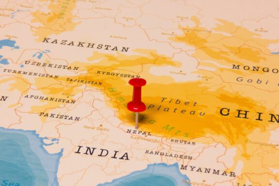
It’s the home of the tallest mountain in the world, the birthplace of the Buddha, and a country with a unique cultural heritage. But where is Nepal exactly?
Nepal is located in the Himalayas of South Asia and is part of the Asian continent.
Precise Location Coordinates of Nepal
The DMS (Degrees, Minutes, Seconds) coordinates for the center of Nepal are:
- 28° 23′ 41.49” N
- 84° 7′ 26.43” E
The latitude and longitude of Nepal are:
- Latitude: 28.394857
- Longitude: 84.124008
You can see the location of Nepal on the world map below:
Nepal Interesting Facts

- Eight of the highest mountains in the world are in Nepal.
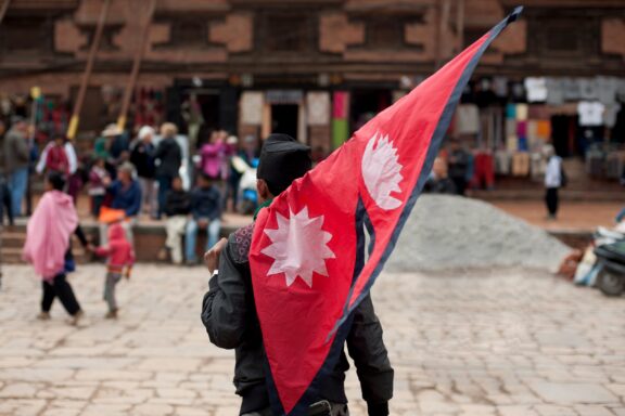
- The flag of Nepal is the world’s only non-quadrilateral national flag.
- Siddhartha Gautama, the Buddha, was born in the Lumbini Province of Nepal.
Nepal Neighboring Countries
Nepal shares international borders with two other countries: China and India. Its longest border is shared with India, and it borders the Tibet Autonomous Region of China.
Nepal is also narrowly separated from Bhutan and Bangladesh by India.
The neighboring countries of Nepal (NP) are:
Maritime Borders
Nepal is a landlocked country and has no maritime borders. The nearest sea is the Bay of Bengal in the Indian Ocean, 644 kilometers (400 miles) to the southeast.

Administrative Divisions of Nepal

The primary administrative divisions of Nepal are its seven provinces. These were formally established with the release of the country’s new 2015 constitution. Each of these provinces is headed by a governor who is appointed by the President of Nepal.
Madhesh Province is the most populous, but also the smallest province in size. The large province in Nepal by area is Karnali, which contains the northernmost point in the country. Kathmandu, the capital of Nepal, is located in Bagmati Province.
Each of Nepal’s seven provinces is further divided into districts, of which there are 77. Each of these is headed by a District Coordination Committee. The smallest administrative division in Nepal consists of urban and rural municipalities.
Geography of Nepal
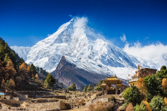
To talk about the geography of Nepal is to talk about the Great Himalayan Mountain Range, mountains famous for their extraordinary height and popularity among the world’s best climbers.
The country of Nepal can be divided into three different physiographic regions: Himal, Pahad, and Terai. Each of these belts is situated lengthwise across Nepal. The country covers a total area of 147,516 km2 (56,956 mi2).
Himal is the northernmost stretch of Nepal and is what many people may picture when thinking of the country’s snow-capped mega mountains. This is where Mount Everest is located, along with several other mountains that reach heights of over 8,000 meters.
The Pahad region of Nepal also consists of many mountains, but these are lower in altitude and generally do not feature snow. The valleys in this region often have high population densities.
The southernmost parts of Nepal belong to the Terai region, which consists of lowland plains and borders India. Some hill ranges are located in this lowland region, and it is fed by several rivers.
History of Nepal
The history of Nepal dates back many thousands of years to the first human inhabitants of the area around the 7th century BCE. They were likely part of the Kirantis or Indus Valley Civilization and were domesticating crops and animals as well as constructing permanent buildings by this time.
The Kirantis ruled in Nepal for hundreds of years until the Lichhavis people arrived from Northern India and took control around 300 CE. The Lichhavis ruled for several centuries and developed good relationships with neighboring Tibet during this time. The Changu Narayan temple from this era is listed as part of the Kathmandu Valley UNESCO World Heritage Site.
After the Kirantis, the next dynasty to control Nepal belonged to the Mallas, who were in power from the 10th to the 18th century. A strong legal and social code influenced by Hindu principles was established during this time, and the society experienced a sort of golden age of creativity.
Arts like literature and music were encouraged during this time, religious festivals were established, and cities became more organized. The Malla Dynasty was divided into three kingdoms during this time: Kathmandu, Patan, and Bhaktapur.
The Shah Dynasty, named after Gorkha King Prithvi Narayan Shah, began its rule after conquering all three kingdoms in the 18th century. The Shah Dynasty would control the area from 1769 until 2008, and it was during this time that Nepal was unified for the first time and its capital became Kathmandu.
The 1990s and early 2000s were marked by great instability in the organization of Nepal’s monarchy. It was finally agreed in 2007 that the monarchy would be abolished, and the Unified Communist Party of Nepal (Maoist) won the 2008 elections. Nepal became a democratic republic.
In more recent history, the Gorkha Earthquake in 2015 caused massive damages to the country and claimed many lives.
Culture and People of Nepal
According to the latest 2021 census in Nepal, the country had a population of 29,192,480, which was a 10.18% growth in population since 2011. The people of Nepal are multi-ethnic, multi-lingual, and practice a variety of different customs and traditions. Read on to learn more about the different people living in this Himalayan county.
Ethnicity and Language
Citizens of Nepal are referred to as Nepali or Nepalese, and there are 126 distinct ethnic groups in the country that speak 123 different languages. No single ethnic group makes up the majority of the population; the largest ethnic group is Chhetri, which accounts for 16.6% of the population.
Nepali is the official language of Nepal, functions as a lingua franca between different ethnic groups, and is spoken as a mother tongue by 44.6% of people in the country. All mother tongues are recognized as minority national languages in Nepal.
Religion
Nepal is a secular state as defined by its constitution, but the majority of its people, 83% in 2011, practice Hinduism. In fact, Nepal was a Hindu Kingdom until 2008, when it became a secular nation for the first time.
The next largest religious group is Buddhists, which account for about 9% of the population. Nepal’s province of Lumbini is renowned for being the birthplace of Gautama the Buddha, the founder of Buddhism, and Buddhist temples can be found throughout the country.
Other major religions in Nepal are Islam, Kirant, and Christianity.
Cuisine
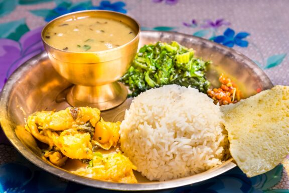
The mainstays of Nepalese cuisine are rice, wheat, corn, and lentils. The most common dish in Nepal is Dal Bhat, a plate of lentil soup and steamed rice, often accompanied by vegetables and sometimes supplemented with meat.
Another common dish in Nepal is Momos, which is a plate of steamed or fried dumplings stuffed with vegetables or meat.
Arts
The many forms of art in Nepal have had centuries to develop and have been influenced by a wide range of cultures. The diversity of Nepal’s people is expressed in the music, dance, literature, crafts, and folk traditions in the country.
One of the traditional dances performed in Nepal is the Dishka, which is performed at weddings. It involves intricate footwork and is paired with music that represents different aspects of daily village life.
There are several festivals celebrated throughout the year in Nepal, and one of the longest and most significant is Dashain. It occurs just after the end of the monsoon season and is celebrated as “a day of victory over demons.”
Biggest Cities in Nepal
Here are the largest cities in Nepal based on 2021 data:
| City | Population |
|---|
| Kathmandu | 975,453 | Pokhara | 353,841 | Jitpur | 337,785 | Biratnagar | 242,548 | Ghorahi | 156,164 | Bharatpur | 143,836 | Birganj | 135,904 | Butwal | 118,462 | Dharan | 116,181 | Dhangadhi | 101,970 |
Map of Nepal with the Largest Cities
Nepal Economy Facts
| World Bank Income Group | Lower middle income |
| World Bank Region | South Asia |
| Currency | Nepalese Rupee (NPR) |
| GDP in 2020 | $33.4 (billions of USD) World Rank: 97 |
| GDP per capita in 2020 | $1,147 World Rank: 165 |
| Major Industries / Economic Sectors | Agriculture, manufacturing, energy, services |
| Top 5 Import Countries | India, China, United Arab Emirates, United States, Japan |
| Top 5 Export Countries | India, United States, China, Germany, United Kingdom |
Government and Politics in Nepal
Nepal has been a parliamentary republic since 2006, after the abolition of the Nepali monarchy. The head of state is the president, whose role is largely symbolic, and the prime minister is the head of the executive. The prime minister is appointed by the Parliament.
The current prime minister of Nepal is Pushpa Kamal Dahal, who was most recently sworn in during 2022 but had previously served in 2008 as the country’s first prime minister and again held the office in 2016 and 2017.
According to the 2022 Democracy Index, Nepal is classified as a “hybrid regime,” a ranking placed between “flawed democracy” and “authoritarian regime.”
Tourist Attractions in Nepal
Roughly 1.2 million tourists arrived in Nepal during 2019; these were most represented by Indian, Chinese, and US tourists. Among the many reasons to visit Nepal, its unique natural and cultural beauty are the primary draws. We’ll look at some of the top tourist attractions in Nepal in this section.
Boudhanath Stupa

Located on the outskirts of Kathmandu, this Buddhist temple is said to contain the remains of one of the ancient Buddhas. It is one of the largest spherical stupas in the world and is a highly popular place for people to worship or visit.
Crowds of people can be seen circling the stupa in a clockwise circle each day, and various cafes, tea shops, and craft stalls are located in the vicinity.
Pashupatinath Temple
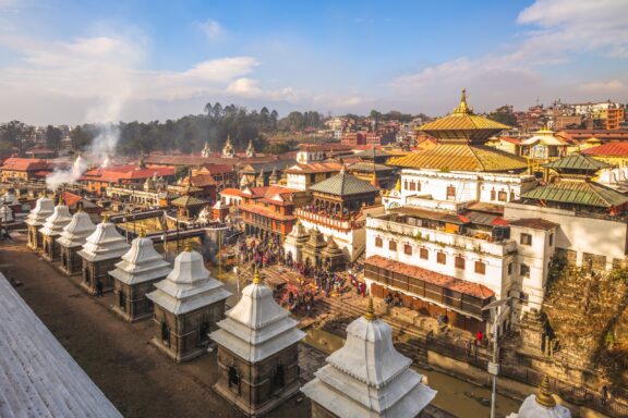
This huge Hindu temple complex lies along the banks of the Bagmati River in Kathmandu. It was completed in the 17th century and is an important religious site for Hindus. Pashupatinath Temple is dedicated to Pashupati, one of the incarnations of Shiva.
Only practicing Hindus of South Asian descent are permitted to enter the temple’s inner courtyard. Non-Hindus can observe the temple from across the river. A small entry fee must be paid to enter the grounds, and visitors should remain aware of the monkeys in the area.
Trekking
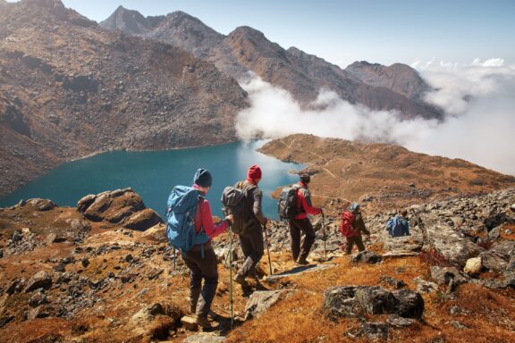
Trekking is undoubtedly one of the most noteworthy attractions in Nepal and something the country is famous for. Incredible access to the Himalayas provides a multitude of mountain trekking options of all difficulty levels, from beginner to expert.
One of the most famous treks, though perhaps not best-suited to the beginner or casual hiker, is the Annapurna Circuit. This multi-week excursion takes adventurers through more than 160 kilometers (100 miles) of the Himalayas to the top of Thorung La Pass at 5416 meters (17769 feet) above sea level.
Transportation and Infrastructure of Nepal
Overland access to Nepal is only available via its two neighboring countries: China and India. Arriving overland from China must be done by car or bus and is only possible through the Gyirong Port. Access to Nepal from India is possible by personal vehicle, bus, or train through six entry points.
For many visitors, international flights are the best way to reach Nepal. The country has three international airports: Tribhuvan International Airport in Kathmandu, Gautam Buddha International Airport in Lumbini, and Pokhara International Airport in Pokhara.
Once in the country, taxis, rickshaws, and buses are the most common forms of travel. Negotiating prices is often necessary with these forms of travel as there are no fixed prices. Some taxis may use meters to determine prices.
Climate and Weather of Nepal
The climate in Nepal varies greatly with altitude. The lower elevations of the country have a subtropical monsoon climate with a wet season that begins in June, and the highest elevations feature an alpine climate with heavy snowfall.
The coldest months in Nepal are December and January, and the best months to visit the country are often considered to be October and November when skies are clearer and it is mostly dry.
Nepal Related Content
Nepal Key Facts
| Country | Nepal |
| Coordinates | Latitude: 28.394857 Longitude: 84.124008 |
| Country Codes | Alpha 2: NP Alpha 3: NPL |
| Country Flag Emoji | 🇳🇵 |
| Int. Phone Prefix | +977 |
| Capital city | Kathmandu |
| Continent Subcontinent | Asia Central & South Asia |
| Country Area | 147,181 sq km |
| Population 2021 | 29,674,920 World Rank: 49 |
| Median Age | 23.7 |
| Life expectancy | 68.5 |
| Major languages | Nepali (official) 44.6%, Maithali 11.7%, Bhojpuri 6%, Tharu 5.8%, Tamang 5.1%, Newar 3.2%, Bajjika 3%, Magar 3%, Doteli 3%, Urdu 2.6%, Avadhi 1.9%, Limbu 1.3%, Gurung 1.2%, Baitadeli 1%, other 6.4%, unspecified 0.2% (2011 est.) |
| UTC/GMT Time | Number of time zones: 1
|
| Internet TLD | .np |
| Biggest Airport | Tribhuvan International Airport (LUA) |
| Average temperature | 8.10 °C 46.58 °F |
| Administrative Divisions | 5 development regions 7 provinces 14 zones |
| Political system | Federal parliamentary democratic republic |
Image Sources and Copyright Information
- Map of India and Surrounding Countries: © P. H. Furian/Shutterstock