New Zealand is located in the Australia and Oceania region at latitude -40.900557 and longitude 174.885971 and is part of the Oceania continent.
The DMS coordinates for the center of the country are:
- 40° 54' 2.01'' S
- 174° 53' 9.50'' E
You can see the location of New Zealand on the world map below:
The country has no neighboring countries/land borders.
Maritime Borders
New Zealand borders with the Pacific Ocean.
New Zealand Related Content
New Zealand Key Facts
| Country | New Zealand |
| Coordinates | Latitude: -40.900557 Longitude: 174.885971 |
| Country Codes | Alpha 2: NZ Alpha 3: NZL |
| Country Flag Emoji | 🇳🇿 |
| Int. Phone Prefix | +64 |
| Capital city | Wellington |
| Continent Subcontinent | Oceania Australia and Oceania |
| Country Area | 268,838 sq km |
| Population 2021 | 5,122,600 World Rank: 122 |
| Median Age | 36.5 |
| Life expectancy | 82.5 |
| Major languages | English (de facto official) 95.4%, Maori (de jure official) 4%, Samoan 2.2%, Northern Chinese 2%, Hindi 1.5%, French 1.2%, Yue 1.1%, New Zealand Sign Language (de jure official) .5%, other or not stated 17.2% (2018 est.) |
| UTC/GMT Time | Number of time zones: 5
|
| Internet TLD | .nz |
| Biggest Airport | Auckland Airport (AKL) |
| Average temperature | 10.55 °C 50.99 °F |
| Administrative Divisions | 16 regions 1 special island authority |
| Political system | Parliamentary democracy |
New Zealand Economy Facts
| World Bank Income Group | High income |
| World Bank Region | East Asia & Pacific |
| Currency | New Zealand Dollar (NZD) |
| GDP in 2020 | $211.7 (billions of USD) World Rank: 49 |
| GDP per capita in 2020 | $41,597 World Rank: 22 |
| Major Industries / Economic Sectors | Manufacturing, services, agriculture, energy |
| Top 5 Import Countries | China, Australia, United States, Japan, Germany |
| Top 5 Export Countries | Australia, United States, China, Japan, United Kingdom |
Biggest Cities in New Zealand
Here are the largest cities in New Zealand based on 2021 data:
| City | Population |
|---|
| Auckland | 1,346,091 | Wellington | 418,500 | Christchurch | 383,200 | Manukau City | 375,600 | Waitakere | 208,100 | Northcote | 205,605 | Hamilton | 176,500 | Tauranga | 135,000 | Lower Hutt | 103,400 | Dunedin | 99,885 |
Map of New Zealand with the Largest Cities
Other Countries in the Australia and Oceania Region
New Zealand Maps and Regions
One of the most desirable vacation destinations on the planet, the nation of New Zealand sits south and east of the continent of Australia. This country is known for its jaw-dropping natural beauty and fascinating indigenous cultures. New Zealand is a must-see country for world travelers.
New Zealand is two islands, the North and South Island. Each island has characteristics, regions, and major cities that make them distinct. New Zealand is in a remote location in the vast Pacific Ocean. Therefore this landmass is considered the last to be settled by humans.
The Islands are separated by the Cook Strait, a narrow passage of water. This strait is only 14 miles wide at its narrowest point but is considered dangerous and difficult to predict. Ferries connect these two islands and run continuously throughout the day.
While New Zealand has become very Westernized, the indigenous Maori people are still present on the islands. Many people may know the Maori people for their signature tattooing tradition, where men and women will even tattoo their faces.
Because of colonization by the British until the 1940s, the Queen of England still influences the nation of New Zealand. Queen Elizabeth appoints a governor-general and still has a say in matters like choosing ambassadors and other certain reserved powers.
New Zealand is also well known for its dominance in the global sport of rugby. Rugby teams perform a ceremonial dance called the haka before each match. This dance celebrates memorable moments. Previously, the haka primarily intimidated enemies before a war.
This country exists along active Pacific and Australian tectonic plates. This positioning makes New Zealand ripe for volcanoes and earthquakes throughout its history. The climate of New Zealand is temperate and mild, with unique biodiversity like the flightless kiwi bird.
In the paragraphs to come, we will highlight the essential regions of the islands of New Zealand and explain New Zealand’s place on the world map. This unforgettable locale overflows with unique details that make New Zealand a fascinating place to live and visit.
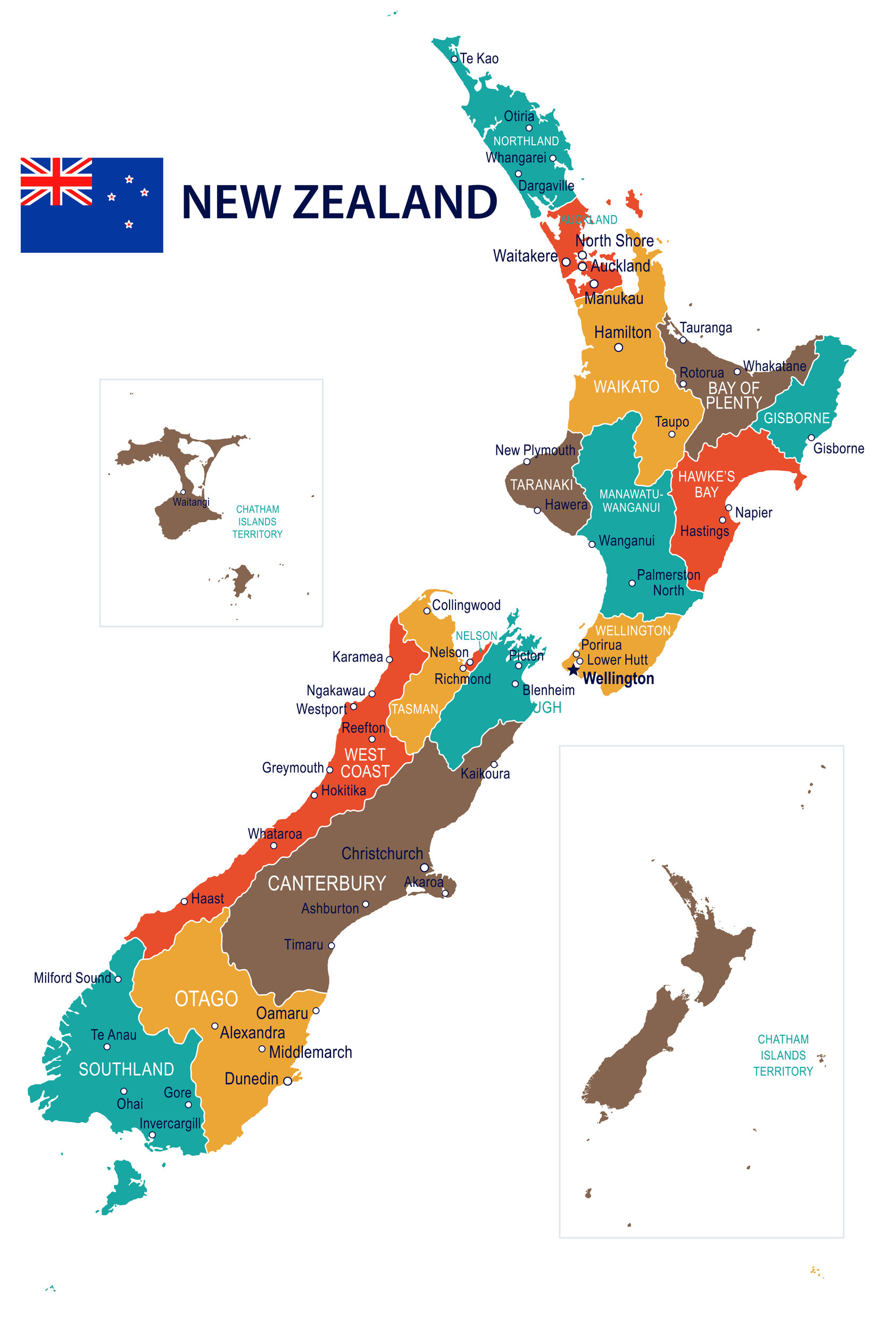
New Zealand Political Map
A political map details cities, regions, and other man-made boundaries. More than five million people live throughout New Zealand, in remote rural areas and bustling cities. New Zealand was a British colony but earned its independence in 1947.
The population is densest near the coasts on both the North and South Island of New Zealand. Cities like Auckland and the capital city of Wellington are on the North Island. Christchurch is the largest city on the South Island and holds its largest airport.
However, New Zealand consists of more than 700 individual landmasses. The Realm of New Zealand also includes Tokelau, the Cook Islands, the self-governing Niue states, and the Ross Dependency. The Ross Dependency is New Zealand’s claim to territory in Antarctica.
New Zealand on the World Map
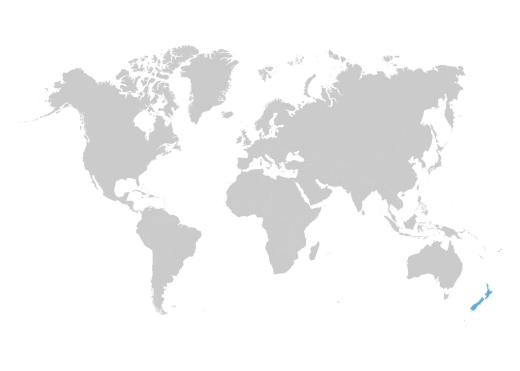
The islands of New Zealand cling to the bottom of a standard world map, between the continents of Australia and Antarctica. New Zealand lies about 1,200 miles east of Australia in the Tasman Sea and about 600 miles south of New Caledonia, Fiji, and Tonga.
New Zealand is a long and skinny nation. This country only measures a maximum width of 250 miles and has 9,300 miles of coastline. The South Island is much larger than the North Island and has impressive mountains like the Southern Alps. The North Island has many volcanoes.
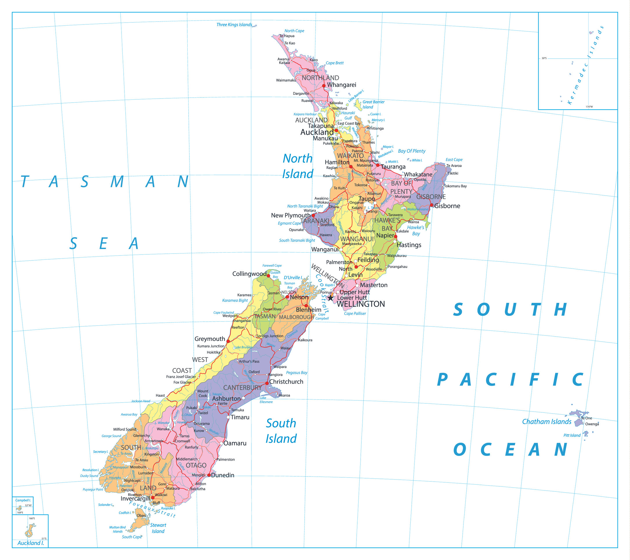
New Zealand Regions and Cities Map
New Zealand supports several unique regions and dynamic cities within its two major islands. This map shows the islands divided into individual regions. These small portions are similar to states in the United States or provinces in Canada.
On the North Island, regions often share their name with the most populous city, like the Auckland or Wellington regions. The Waikato region is home to the city of Hamilton, another large and notable city on the North Island. The North Island contains nine regions.
The South Island contains seven unique regions to divide this unique nation. Unlike the North Island, the regions of the South Island are much larger. The Canterbury region has Christchurch and is the largest region that dominates the east coast of South Island.
Regions of New Zealand
New Zealand is organized into sixteen regions for purposes of its political map and societal organization. These regions are relatively young, with the 16 we know today established in 1989. Before 1989, New Zealand managed more than 700 random independent regions.
These regions were organized based on natural resources, a highlight of New Zealand society. The people of this island are very connected to the environment and make thoughtful decisions to maintain its natural sanctuaries.
Nine North Island Regions
The nine regions of New Zealand’s North Island are, from north to south:
- Northland
- Auckland
- Waikato
- Bay of Plenty
- Gisborne
- Manawatu-Wanganui
- Hawkes Bay
- Taranaki
- Wellington
Northland is the northernmost tip of the North Island, with a population totaling just under 200,000 people. This region continues to grow and enjoys a steady climate year-round. This consistent temperature earns it the nickname of the “Winterless North.”
The Auckland region contains the largest city in the entire country, Auckland. This region has the largest economy and number of people who reside within its borders, but a relatively small landmass.
This region has peninsulas throughout, making it an economic hub for shipping, cargo, and international airline travel. Auckland is the most notable city in New Zealand and is the urban destination for most high-profile activity in New Zealand.
The Waikato region is by the city of Hamilton. The word “Waikato” is the Maori, or indigenous people of New Zealand’s, word for flowing water. This region is dominated by the Waikato River and its natural connection to the major waterways of the Tasman Sea.
The Bay of Plenty is known for its historical significance of being the place where the first Maori settlers landed to inhabit this island. This region is made of several islands that contain eight major rivers of this country.
Gisborne is commonly referred to as the East Coast region. This region is situated on the northeast corner of the North Island. Its boundaries are made of an extensive collection of mountain ranges, formed over centuries of earthquake activity.
The Hawke’s Bay region is rural, fertile, and hilly. This region is known for its agriculture. It has many renowned vineyards and orchards. Iconic groups of herd animals like cows and sheep dot the landscape.
The Taranaki region is known for its signature volcano, Mount Taranaki, and is located on the far west coast of the North Island.
Manawatu-Wanganui is a region that takes up most of the southern half of the North Island. This vital region contains two major rivers. Throughout its history, this region was important for the transportation and commerce available by using these waterways.
The final region of the North Island is Wellington, which contains the capital city of New Zealand. This region is the southern tip of the North Island. Wellington is a major hub of New Zealand, with the country’s largest airport.
Seven South Island Regions
The seven regions of the South Island are:
- Tasman
- Nelson
- Marlborough
- West Cost
- Canterbury
- Otago
- Southland
The Tasman region lies in the northwest corner of the South Island. This region is primarily small towns, with populations less than 1,000.
The Nelson region is the oldest region on the South Island. This region is known for its thriving arts and culture, celebrating its status as the oldest city in New Zealand.
The Marlborough region is recognized for its dry climate. This region is located on the northeast coast of the South Island, stretching toward Wellington. The wine varietal, Sauvignon Blanc, thrives here.
The West Coast region stretches all along the west coast of the South Island, one of the much larger regions of the South Island. This narrow region is remote and sparsely populated.
In direct contrast, the Canterbury region is a large South Island region. This region has the largest city, Christchurch. Almost two-thirds of the South Island’s population lives here.
Otago is the second largest region in New Zealand. Otago takes up much of the southern half of the island. This region boasts large urban areas like Queenstown and gorgeous glacial lakes and mountains.
Southland rounds out the South Island, with this region that stretches toward New Zealand’s territorial claim in Antarctica. This stunning region contains the largest national park in the country, Fiordland National Park.
New Zealand is a destination that must be seen to be believed. The 16 individual regions of this nation are unique but are all connected by this country’s beautiful landscapes. Rolling hills, volcanoes, mountain peaks, and fertile valleys are common across New Zealand.
These islands are overflowing with culture, biodiversity, and thriving cities. While a very remote place, this country is gorgeous. New Zealand’s 16 wonderful regions represent an exceptional example of a successful society in our contemporary time.
Image Sources and Copyright Information
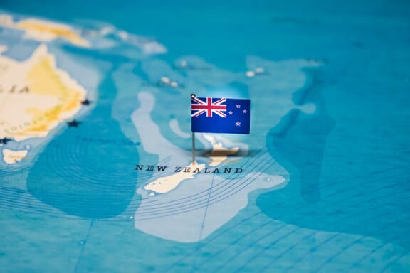
- New Zealand Flag on Map: © hyotographics/Shutterstock