Earthquakes are natural disasters that have the power to totally reshape geographies, cause destruction, and leave lasting impacts on communities. They have played an important role in the history of our planet and continue to make a dramatic impact.
In this post, we’ll learn about the 20 biggest earthquakes in the world according to the United States Geological Survey (USGS), from the beginning of the 20th century to the present. Some caused massive tsunamis and led to large-scale human suffering, and others had much smaller impacts on humans.
We’ll explore all of the largest earthquakes, from 8.4 magnitude quakes off the shores of Japan and Peru to the biggest earthquake in the world: Chile’s 9.5 magnitude earthquake in 1960.
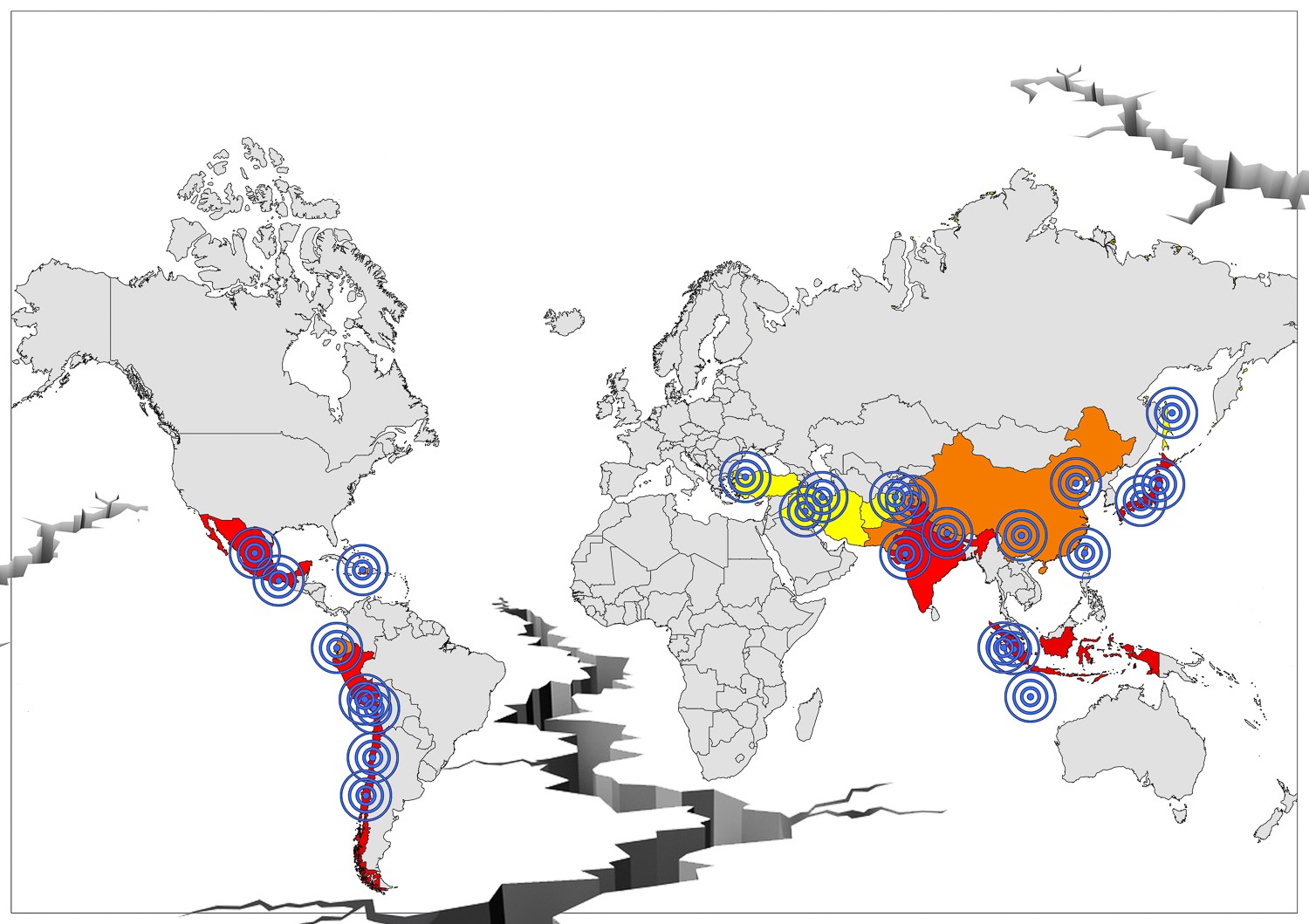
Interactive Map of the Biggest Earthquakes in the World
What is earthquake magnitude?
Magnitude vs. Intensity
The magnitude of an earthquake is a measure of the total energy produced by the earthquake. The intensity of an earthquake varies by distance from the hypocenter, depth of the hypocenter, and the local soil and rock composition.
The nearer and shallower the hypocenter of an earthquake, the greater the intensity. The intensity of an earthquake is also greater in areas with softer, looser soil composition than those consisting of bedrock.
Richter Scale vs. Moment Magnitude Scale
The Richter scale and moment magnitude scale both measure the magnitude of earthquakes, but the latter is more accurate. This is especially true for earthquakes with a magnitude greater than M5.
The Richter scale was developed in 1934, and the moment magnitude scale was developed in the 1970s.
Modified Mercalli Intensity Scale
This scale measures the perceived effects of an earthquake. Lower levels are mostly defined by the effects experienced by people, and higher levels are usually described by the effects experienced by buildings and larger structures.
20 Biggest Earthquakes in the World
| Rank | Location | Year | Magnitude |
| 1. | Bio-Bio Region, Chile | 1960 | 9.5 |
| 2. | Southern Alaska | 1964 | 9.2 |
| 3. | West Coast of Northern Sumatra | 2004 | 9.1 |
| 4. | Japan, east of Honshu | 2011 | 9.1 |
| 5. | Kamchatka Peninsula | 1952 | 9.0 |
| 6. | Offshore Bio-Bio, Chile | 2010 | 8.8 |
| 7. | Near the coast of Ecuador | 1906 | 8.8 |
| 8. | Rat Islands, Alaska | 1965 | 8.7 |
| 9. | Assam, Tibet | 1950 | 8.6 |
| 10. | West Coast of North Sumatra | 2012 | 8.6 |
| 11. | North Sumatra, Indonesia | 2005 | 8.6 |
| 12. | Andreanof Islands, Aleutian Islands, Alaska | 1957 | 8.6 |
| 13. | South of Alaska | 1946 | 8.6 |
| 14. | Banda Sea, Indonesia | 1938 | 8.5 |
| 15. | Atacama, Chile | 1922 | 8.5 |
| 16. | Kuril Islands | 1963 | 8.5 |
| 17. | Near the East Coast of the Kamchatka Peninsula | 1923 | 8.4 |
| 18. | Southern Sumatra, Indonesia | 2007 | 8.4 |
| 19. | Southern Peru | 2001 | 8.4 |
| 20. | Off the East Coast of Honshu, Japan | 1933 | 8.4 |
20. Off the East Coast of Honshu, Japan

Year: 1933
Magnitude: 8.4
The earthquake that struck off the east coast of Honshu, Japan in 1933 was a monumental event with a magnitude of 8.4 on the Richter scale. Occurring on March 2nd, it is often referred to as the Sanriku earthquake, drawing its name from Japan’s northeastern Sanriku Coast, which has a history of being affected by powerful tsunamis.
The 1933 quake triggered a devastating tsunami that reached heights of up to 28.7 meters (94.2 feet) in some areas. This catastrophic combination of the earthquake and subsequent tsunami resulted in the unfortunate loss of over 3,000 lives. Coastal towns were severely impacted, with many homes and buildings destroyed.
This earthquake took place in the Pacific’s Ring of Fire, an area that is especially prone to earthquakes.
19. Near the Coast of Southern Peru

Year: 2001
Magnitude: 8.4
This earthquake near the coast of Southern Peru in 2001 was a significant seismic event, registering an 8.4 on the Richter scale. It took place in June and deeply affected the regions of Arequipa, Moquegua, and Tacna.
The tremors led to the collapse of numerous buildings, infrastructure damage, and landslides in affected areas. Many homes were destroyed, thousands of people were injured, and nearly 100 lost their lives.
The earthquake also produced small tsunamis, with waves reaching the coasts of New Zealand, Japan, and the United States. The international community swiftly responded with aid, highlighting the profound global impact and compassion following natural disasters.
18. Southern Sumatra, Indonesia

Year: 2007
Magnitude: 8.4
Another earthquake with a magnitude of 8.4 on this list of the world’s biggest earthquakes occurred in Southern Sumatra, Indonesia in 2007. On September 12th, the earthquake emanated from a seismically active region under the Indian Ocean, an area notorious for generating powerful earthquakes.
The quake was responsible for the unfortunate deaths of twenty-five people, with many more injured. The tremors damaged thousands of homes and structures across Sumatra, displacing numerous residents and causing significant economic disruptions.
A series of tsunamis were generated by this earthquake that affected coastal areas and added to the overall devastation. Indonesia is also located in the Pacific Ring of Fire and is no stranger to strong earthquakes such as this one, though the effects are still disastrous.
17. Near the East Coast of Kamchatka Peninsula, Russia

Year: 1923
Magnitude: 8.4
Number 17 on this list of the biggest earthquakes in the world belongs to the 1923 quake that occurred near the east coast of the Kamchatka Peninsula in Russia’s Far East region. Measuring a magnitude of 8.4 on February 3rd, this seismic event was one of the most powerful in the history of the region.
Kamchatka, a part of the Pacific Ring of Fire, is a hotspot for tectonic activity due to the movement of the Pacific Plate beneath the North American Plate.
This 1923 quake resulted in notable land deformations and triggered tsunamis that traveled across the Pacific, causing alerts in distant coastal regions such as Hawaii. Although the peninsula was sparsely populated during this time, the local indigenous communities faced significant hardships due to the destruction of their homes and fishing areas.
16. Kuril Islands

Year: 1963
Magnitude: 8.5
In 1963, the Kuril Islands, an archipelago located between Russia’s Kamchatka Peninsula and Japan’s Hokkaido Island, experienced an earthquake with a magnitude of 8.5. Although seismic activity is a fairly common occurrence in the Kuril Islands, this was the strongest recorded in the region.
The quake’s epicenter was under the ocean, leading to concerns about potential tsunamis, and waves generated by the quake were observed in Canada, Japan, Mexico, Hawaii, Alaska, and California.
Fortunately, the direct human toll on the sparsely populated islands was limited, but there were significant infrastructural damages. This event underscored the region’s vulnerability to seismic activity and emphasized the importance of preparedness measures for such a remote area.
15. Atacama, Chile

Year: 1922
Magnitude: 8.5
On November 11, 1922, a powerful earthquake with a magnitude of 8.5 rocked the Atacama region, located in northern Chile. Large earthquakes are common here, as the region is one of the most seismically active zones in the world.
The 1922 quake’s devastation was profound. Coastal towns and villages in the Atacama area suffered greatly with widespread destruction of infrastructure, homes, and buildings. The city of Vallenar was especially affected, and the event is sometimes called the Vallenar Earthquake.
The earthquake also triggered a formidable tsunami that not only affected the Chilean coastline but also reached across the Pacific, with recorded wave heights in places as far away as Australia.
14. Banda Sea

Year: 1938
Magnitude: 8.5
Another major earthquake with a magnitude of 8.5 occurred in 1938 in the Banda Sea, which is surrounded by several islands in eastern Indonesia. The earthquake took place on the first of February and is still one of the strongest to have shocked the region.
Due to the size of the Banda Sea and the location of the earthquake’s hypocenter, the direct impact on land was somewhat limited. The tremors were felt strongly on surrounding islands, however, resulting in structural damage in some areas.
This quake created tsunamis with waves that reached various coastal regions but did not cause any loss of life.
13. South of Alaska

Year: 1946
Magnitude: 8.6
On April 1st, 1946, the region south of Alaska was shaken by a massive earthquake registering 8.6 on the Richter scale. This earthquake was particularly notable not only for its sheer magnitude but also for the devastation it caused.
The quake’s epicenter was near Unimak Island, and the resultant force triggered a tsunami that destroyed the island’s Scotch Cap Lighthouse and led to the deaths of its five-person crew.
The massive waves from the resulting tsunami also reached as far as California and Hawaii, where local residents had no warning, and caused 165 deaths. The damage caused by the tsunami led to the development of what would become the Pacific Tsunami Warning Center
12. Andreanof Islands, Aleutian Islands, Alaska

Year: 1957
Magnitude: 8.6
The Andreanof Islands are part of the Aleutian Island chain that stretches from Alaska to Russia. They are located along a subduction zone where the Pacific Plate dives beneath the North American Plate, a tectonic boundary that has been the source of many major earthquakes throughout history.
In 1957, an 8.6 magnitude earthquake struck beneath the ocean in the area and resulted in a significant tsunami. The tsunami traveled great distances and affected coastal regions across the Pacific. Fortunately, no lives were lost, but significant structural damage was suffered in Hawaii.
11. Northern Sumatra, Indonesia

Year: 2005
Magnitude: 8.6
Northern Sumatra, a region in Indonesia, felt the tremors of a significant earthquake on March 28, 2005 that registered a magnitude of 8.6. This earthquake occurred just a few months after the devastating 2004 Sumatra-Andaman quake and tsunami, which had a profound impact on the Indian Ocean region.
The 2005 quake’s epicenter was located close to Nias Island, off the western coast of Sumatra. The island experienced substantial destruction, with many buildings, especially traditional structures, collapsing, leading to the loss of at least 1,000 lives.
The quake also caused a tsunami, though its effects were relatively limited compared to the 2004 event.
10. Off the West Coast of Northern Sumatra
Year: 2012
Magnitude: 8.6
Yet another massive earthquake to occur near Indonesia’s Northern Sumatra jolted the region in 2012, registering a magnitude of 8.6. It was remarkable for being one of the largest strike-slip events ever recorded. Unlike typical subduction zone quakes in the area, this was primarily a horizontal displacement of the tectonic plates.
Although the potential for a devastating tsunami was high given the magnitude, the nature of the quake did not produce large vertical displacements in the ocean floor, which are typically responsible for generating tsunamis. Because of this, the resultant tsunamis were relatively small.
9. Assam-Tibet

Year: 1950
Magnitude: 8.6
On August 15, 1950, the region along the Eastern Xizang-India border experienced a massive earthquake with a magnitude of 8.6.
This region, spanning the border areas of Tibet and India’s northeastern state of Assam, lies in a seismically active zone due to the collision between the Indian and Eurasian tectonic plates. This is also responsible for the great heights of the Himalayas, which host many of the tallest mountains in the world.
This incident, often referred to as the Assam-Tibet earthquake, stands as one of the most potent in recorded history. It caused widespread destruction, especially in Assam, where towns like Dibrugarh and Tezpur faced significant damage.
8. Rat Islands, Aleutian Islands, Alaska

Year: 1965
Magnitude: 8.7
The eighth-biggest earthquake in the world since 1900 happened on February 4, 1965, near the Rat Islands in the Aleutian Islands chain between Alaska and Russia. It had a magnitude of 8.7 and created a tsunami that was nearly 10 meters (32.8 feet) high.
Shemya Island received the brunt of the tsunami’s force, but it is sparsely populated, so there was relatively little impact on humans. While more powerful than most, this earthquake was one of many that have occurred in the region, which is a hot spot for seismic activity.
7. Near the Coast of Ecuador
Year: 1906
Magnitude: 8.8
On January 31, 1906, a colossal earthquake with a magnitude of 8.8 struck near the coast of Ecuador. This seismic event is of particular significance because it was one of the earliest mega-quakes of the 20th century to be studied in some detail.
Ecuador is situated in the Pacific Ring of Fire and often experiences seismic activity. This region sees the convergence of the Nazca and South American tectonic plates, leading to frequent and often powerful earthquakes.
A tsunami generated by the 1906 earthquake radiated across the Pacific Ocean, with waves reaching as far as San Francisco and Japan. It caused major damage and took many lives along the coasts of Ecuador and neighboring Colombia, washing away entire communities.
6. Offshore Bio-Bio, Chile

Year: 2010
Magnitude: 8.8
Chile’s geographical positioning along the Pacific “Ring of Fire” makes it one of the most seismically active countries in the world. A devastating example of this activity happened on February 27, 2010, when an 8.8 magnitude earthquake struck offshore of the Bio-Bio region in southern Chile.
The intense shaking lasted for about three minutes, but its impacts were felt for much longer. Across central and southern parts of Chile, buildings collapsed, bridges were destroyed, and roads were damaged, making emergency response efforts challenging.
The earthquake also generated a formidable tsunami with wave heights up to 29 meters (95 feet) that affected not just the Chilean coast but traveled across the Pacific Ocean. Several towns along the Chilean coastline were heavily impacted by the tsunami, with buildings and infrastructure washed away by the force of the waves.
5. Off the East Coast of the Kamchatka Peninsula, Russia

Year: 1952
Magnitude: 9.0
On November 4, 1952, the eastern coast of Russia’s Kamchatka Peninsula was struck by a massive earthquake with a magnitude of 9.0. It remains the fifth-strongest earthquake ever recorded and is the first magnitude 9.0 event on this list of the biggest earthquakes in the world.
The quake’s epicenter was in the deep oceanic trenches where the Pacific Plate subducts beneath the North American Plate. This subduction zone is responsible for the area’s intense volcanic activity and frequent seismic disturbances.
Given its offshore location, the 1952 earthquake caused a formidable tsunami. The waves radiated outwards across the Pacific, reaching Hawaii, Japan, and even as far as New Zealand and California. Fortunately, there were no human casualties as a result of the earthquake or tsunami.
4. Near the East Coast of Honshu, Japan

Year: 2011
Magnitude: 9.1
This is one of the most recent earthquakes on this list in addition to being one of the biggest. On March 11, 2011, a massive earthquake with a magnitude of 9.1 struck near the east coast of Honshu, Japan. The event is also known as the Tōhoku Earthquake or the Great East Japan Earthquake.
The immense force of this earthquake was matched by the widespread destruction and tragedy it caused. The quake consisted of intense shaking that lasted for six minutes, but it was the subsequent tsunami that caused the most profound devastation.
Massive waves, reaching heights of up to 40 meters (131.2 feet) in some areas, inundated the eastern coastline of Honshu, sweeping away entire communities, causing significant damage to infrastructure, and leading to a catastrophic failure at the Fukushima Daiichi Nuclear Power Plant.
The aftermath saw over 18,000 deaths, with thousands more injured and missing. The nuclear meltdown at Fukushima became the worst nuclear accident since the Chernobyl disaster in 1986, leading to widespread evacuations and concerns over radiation contamination.
3. Off the West Coast of Northern Sumatra

Year: 2004
Magnitude: 9.1
Number three on the list of biggest earthquakes in the world happened on December 26, 2004 off the west coast of Northern Sumatra in Indonesia. It had a magnitude of 9.1 and is remembered for the incredible devastation it triggered.
The earthquake generated a catastrophic tsunami that affected the coasts of 14 countries and resulted in the loss of nearly 230,000 lives, making it the deadliest tsunami in history.
Waves reached heights of 30 meters (98.4 feet) in some places, and one of the hardest-hit areas was the Indonesian province of Aceh, where entire towns and villages were washed away.
Coastal regions in Thailand, Sri Lanka, and India also faced profound devastation. Thousands of tourists vacationing in the region were among the casualties, making the disaster’s impact truly international.
Beyond the immediate and overwhelming loss of life, the tsunami led to significant displacement of populations, with millions losing their homes and livelihoods. Despite the danger of future tsunamis, much of the local population has rebuilt their homes and lives in the worst-affected areas.
2. Southern Alaska

Year: 1964
Magnitude: 9.2
The 1964 earthquake in Southern Alaska, also known as the Good Friday Earthquake or the Great Alaska Earthquake, remains the most powerful recorded earthquake in North American history and the second-strongest ever measured worldwide.
Striking on March 28, 1964, with a magnitude of 9.2, the quake lasted approximately 4.5 minutes, causing destructive landslides and a deadly tsunami. The tsunami caused damage not just in Alaska but also along the west coast of the U.S. and as far away as Japan.
The towns of Valdez, Chenega, and Seward were particularly hard hit. Valdez was moved to a new location after the earthquake due to the extensive damage it endured. Of the massive landslides caused by the quake, one in Anchorage led to the destruction of an entire neighborhood.
The immediate aftermath counted 131 casualties, a number that would have been higher had the earthquake not occurred during the early evening of a holiday when the streets and businesses were less crowded.
1. Bio-Bio, Chile

Year: 1960
Magnitude: 9.5
The title of the biggest earthquake in the world belongs to the 1960 earthquake that struck the Bio-Bio region of Chile. The epicenter of the quake was near the city of Valdivia, and its magnitude was a staggering 9.5.
The tremors were so powerful that they caused vast areas of the Chilean coast to rise or sink. In some areas, the coastline was lifted permanently by several meters, resulting in the submersion of parts of the coastal landscape.
The seismic activity also caused a series of tsunamis that radiated across the Pacific Ocean. These waves struck the Chilean coast with devastating force, but they also traveled vast distances, reaching as far as Hawaii, Japan, and the Philippines.
In total, it is estimated that between 490 to 5,700 people lost their lives due to the earthquake and its subsequent effects, and over 2 million people were left homeless. Financially, the damages were astronomical, equivalent to billions of U.S. dollars today.
Biggest Earthquakes FAQs
What is the strongest earthquake ever recorded?
The strongest earthquake ever recorded is the Bio-Bio, Chile earthquake of 1960, with a magnitude of 9.5 on the Richter scale.
How are earthquakes measured?
Earthquakes are typically measured using the Richter scale or the moment magnitude scale (Mw).
Seismographs, which are sensitive devices placed on the Earth’s surface, detect and record the intensity and duration of seismic waves, and this data is then used to calculate the earthquake’s magnitude.
Why do earthquakes happen?
Earthquakes are primarily caused by sudden releases of energy in the Earth’s crust. These releases often happen because of stress induced by the movement of tectonic plates. The friction at plate boundaries or within plates themselves can cause stress to build up until it’s released suddenly, causing an earthquake.
How many earthquakes happen a day?
According to the USGS, the National Earthquake Information Center detects an average of 55 earthquakes each day. Many of these are too small to be noticed by humans.
Where do earthquakes originate?
The point within the Earth where an earthquake originates is called the hypocenter or focus. Directly above the hypocenter, on the Earth’s surface, is the epicenter – the point where the earthquake’s effects are usually most intensely felt.
Where do earthquakes happen the most?
Earthquakes mostly happen along tectonic plate boundaries. The Pacific Ring of Fire, an area where the Pacific Plate meets several other plates, is the world’s most seismically active region, experiencing a large percentage of the world’s significant earthquakes.
Countries in this “ring” include the United States, Japan, Russia, New Zealand, Indonesia, Chile, the Philippines, Peru, and several others.
Image Sources and Copyright Information
- Devastation in Kamaishi: Aftermath of the 1933 Sanriku Earthquake with Damaged Boats and Buildings: Wikimedia Commons | Public Domain Mark 1.0
- Intensity Map of the 2001 Southern Peru Earthquake: © USGS/Wikimedia Commons | Public Domain Mark 1.0
- Tsunami Hazard Zone Sign in East Java, Indonesia: © Antonius Sulistyo/Shutterstock
- Sailing Vessel on the Pacific with Kamchatka Peninsula’s Snow-Capped Mountains in the Background: © Artyom Bezotechestvo/Shutterstock
- Aerial View of White Cliffs Along the Shoreline of Iturup Island, Kuril Islands: © Shchipkova Elena/Shutterstock
- Devastation in the Aftermath of the 1922 Vallenar Earthquake in Atacama, Chile: © Gustavo Bruzzone Rocco/Wikimedia Commons
- Tropical Island Paradise at Dusk with Lush Greenery and Pristine Beaches: © Asril Ma'ruf/Shutterstock
- Evacuation Chaos: People Running for Safety During the 1946 Aleutian Islands Earthquake Aftermath: Wikimedia Commons | Public Domain Mark 1.0
- Powerful Waves Crashing on the Shore with Snow-Capped Mountain in the Background: © Daniel Briem/Shutterstock
- Traditional Village Street with Distinctive Roofed Houses in Nias, Indonesia: © Gunawan Yuli Dwiputra/Shutterstock
- Traditional Indian Temple Architecture in Dibrugarh, Assam: © dkroy/Shutterstock
- Lupine Flowers Along a North Beach Road on Shemya Island: © Lucas Payne/Shutterstock
- Two Police Officers Patrolling a Residential Area with Caution Tape: © erlucho/Shutterstock
- Aerial View of a Coastal Town in the Kuril Islands with Lush Green Hills and Calm Blue Waters: © By Victor Morozov/Wikimedia Commons | CC BY-SA 2.5 Generic
- Devastation in a Japanese Town After the 2011 Tsunami with a Large Boat Stranded on the Street Amidst Ruins: © Fly_and_Dive/Shutterstock
- Devastation in Banda Aceh: Aftermath of the 2004 Tsunami: © Frans Delian/Shutterstock
- Devastation from the 1964 Alaska Earthquake with Collapsed Structures and Debris: © Everett Collection/Shutterstock
- Devastation in Valdivia: Aftermath of the 1960 Earthquake: © Pierre St. Amand/Wikimedia Commons | Public Domain Mark 1.0